Published in:
Blog
Advances in Remote Sensing Technologies for Monitoring River Water Quality
The quality of our rivers and water bodies is vital to the health and well-being of humans and the environment. Monitoring water quality parameters is crucial for effective management and conservation efforts. As per UNESCO, “90% of sewage in developing countries is discharged untreated directly into water bodies. Every day two million tons of sewage and other effluents drain into the world’s water. Industry discharges an estimated 300-400 megatons of waste into water bodies every year.”
From industrial waste, oil pollution, plastic, pesticide, and fertilizer runoff to radioactive pollution, water pollutants are increasing at a dangerous rate, worsening the pollution of freshwater resources. Traditionally, water quality monitoring has relied on manual sampling and laboratory analysis, which can be time-consuming, expensive, and limited in spatial coverage. However, recent advances in remote sensing technologies have revolutionized how we monitor river water quality.
Remote sensing technologies
Remote sensing involves acquiring information about an object or phenomenon without direct physical contact. In water quality monitoring, remote sensing allows us to gather valuable data about various parameters, including temperature, turbidity, chlorophyll-a concentration, dissolved oxygen, and suspended sediments. This data can be collected over large areas, providing a comprehensive and real-time view of the water quality dynamics in rivers. Here are some key developments in remote sensing technologies and their applications for monitoring river water quality.- Hyperspectral imaging using unmanned aerial vehicles (UAVs): Hyperspectral imaging involves capturing high-resolution images across a wide range of the electromagnetic spectrum. It enables the identification and characterization of water constituents based on their unique spectral signatures. By analyzing the reflected light from water bodies, researchers can extract valuable information about water quality parameters such as chlorophyll-a concentration, turbidity, dissolved organic matter, and algal blooms. Hyperspectral imaging can be deployed from airborne or satellite platforms, providing large-scale coverage and real-time monitoring capabilities.
- LiDAR (Light detection and ranging): LiDAR technology utilizes laser pulses to measure the distance between a sensor and the water surface, enabling the creation of high-resolution elevation maps of rivers and their surrounding landscapes. By combining LiDAR data with water quality parameters, such as temperature, conductivity, and nutrient concentrations, researchers can gain valuable insights into the spatial distribution of pollutants and their impact on river ecosystems. LiDAR also facilitates the identification of riverbank erosion, which can contribute to sediment and nutrient loading and affect water quality.
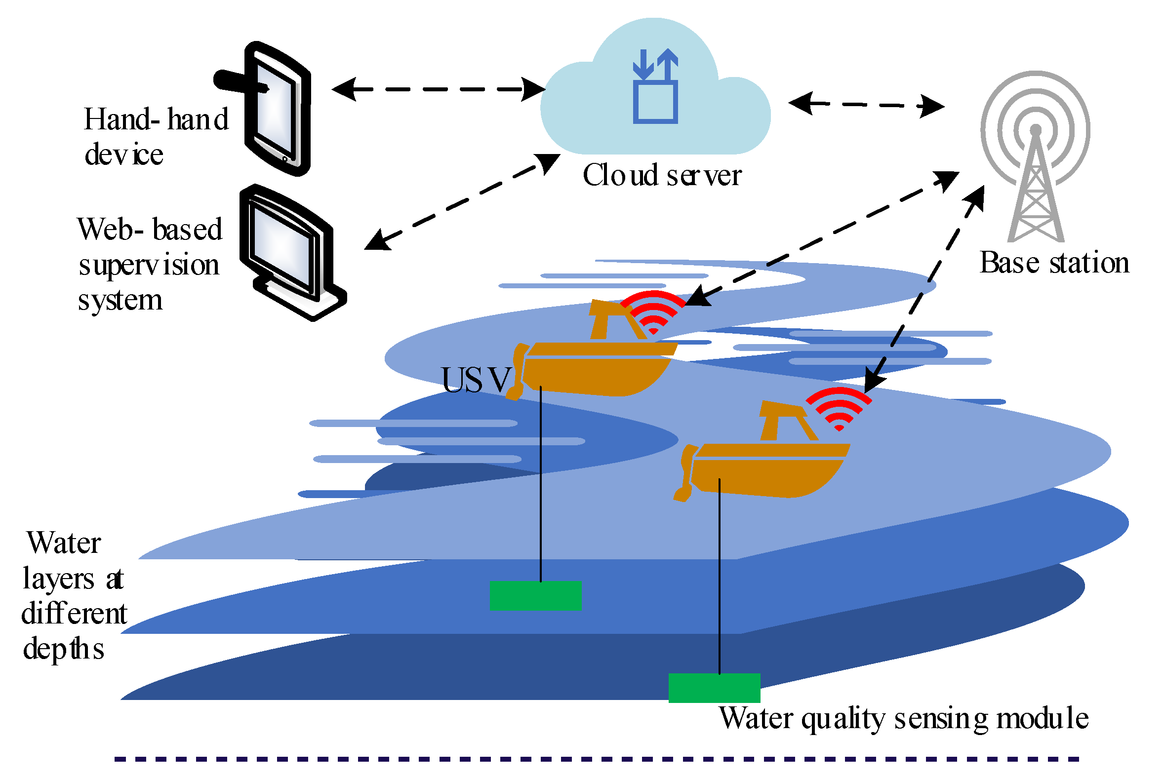
- Sensorization: Electronic sensors have a critical role to play when it comes to assessing river water quality. Sensors are employed to measure a wide range of physical properties of water, such as temperature, pH levels, conductivity, turbidity, and dissolved oxygen, and provide accurate and real-time data on various parameters. Companies can use wide-area wireless communication technology interfaces such as NB-IoT, LoRA, and Sigfox to implement remote monitoring solutions, which help assess temperature, pH levels, conductivity, turbidity, dissolved oxygen, and more in real time.
Application of remote sensing technologies for accurate water quality assessment
Container use has been scarce in small-footprint and long-life cycle edge embedded systems in the operational technology (OT) realm. Embedded devices such as those for industrial, medical, and automotive systems often require lightweight, reliable software with long life cycles. Existing container technologies and platforms, such as those in enterprise Linux, are often bloated or need updates too frequently to run effectively on these embedded systems.- Integration of remote sensing with water quality models: Integrating remote sensing data with water quality models has enhanced our ability to understand and predict changes in river water quality. By assimilating remote sensing data into hydrodynamic and water quality models, scientists can improve the accuracy of water quality predictions and assess the impact of various pollution sources and management practices. This integrated approach allows for more efficient monitoring, evaluation, and implementation of water resource management strategies.
- Water quality mapping using hyperspectral imaging: Remote sensing technologies can create detailed spatial maps of various water quality parameters, including turbidity, chlorophyll-a concentration, ammoniacal nitrogen, reactive phosphorus, total suspended solids, and more. These maps provide a comprehensive view of water quality across large areas, helping identify pollution sources, assess impacts, and guide management strategies. Remote sensing can detect and monitor the presence of harmful substances such as oil spills, chemical pollutants, and heavy metals in water bodies. Hyperspectral and multispectral sensors can identify unique spectral signatures of these substances, enabling early detection and rapid response.
- Real-time sensors: Real-time sensors such as conductivity sensors, pH sensors, dissolved oxygen (DO) sensors, conductivity sensors, turbidity sensors, online spectrophotometers, and others are critical in ensuring the timely and accurate assessment of water conditions. These sensors continuously measure various parameters and provide immediate feedback, allowing for prompt interventions and proactive management. These real-time sensors can be integrated into monitoring networks or deployed as standalone devices at critical monitoring points. The collected data is often transmitted wirelessly to central systems for analysis and visualization, allowing for immediate detection of water quality issues, prompt decision-making, and effective management strategies.
- Remote sensing for harmful algal blooms: Harmful algal blooms (HABs) pose a significant threat to water quality and public health. Remote sensing technologies have greatly improved our ability to detect and monitor HABs in rivers. Satellite-based sensors can detect changes in water color and chlorophyll-a concentrations, indicating the presence of harmful algae. Additionally, advanced algorithms and machine learning techniques can help distinguish between different algal species and estimate toxin concentrations. These capabilities enable early detection and timely response to HAB events, mitigating potential environmental and human health risks. Recently, a project called “Aquawater Australia” was rolled out across the country, which is said to issue the world’s first water quality forecasts. As per reports, researchers will combine data from satellites and sensors on the ground to provide early warning of potentially harmful events such as algal bloom, blackwater, and runoff contamination.